Tip: Maps can be more useful than people expect, especially as more of us are growing up without ever needing to actually use a map for figuring out where we are, plotting a course, or finding water. Learn more about how to read a map and how to use a map and compass
Most important bits:
- You should at least have a national road atlas, a state atlas, and a folding topographic map of the local area you can keep in your go-bag.
- You can also buy detailed maps of individual large cities in your area — especially if you’re likely to pass through it when evacuating.
- If you only have one or two maps total, we generally recommend going with laminated/waterproof maps because the durability benefits outweigh the cons of not being able to write directly on them.
- If buying a laminated folding map, you don’t want ones that fail to fold flatly because the extra thickness of the laminate blocks the creases. Well-designed maps will build extra margin around the crease so that everything folds neatly.
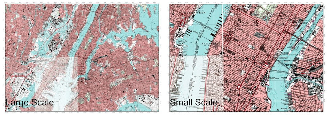
- Scale defines how “zoomed in” a map is. Small-scale maps show more area but less detail. Large-scale maps show more detail but less area.
- For national atlases, both Rand McNally and National Geographic are good and very similar.
- DeLorme makes good state atlases for all 50 states. However, they’re limited in city detail, so you may have to obtain a separate map for individual cities.
- The US Geological Survey and National Geographic both offer free topographic maps you can print yourself or have printed. However, the USGS maps are very large and difficult to print.
- MyTopo offers large, waterproof, custom topographic maps of any area you want.
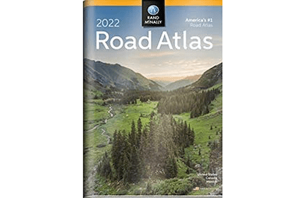
Rand McNally 2022 Road Atlas with Protective Vinyl Cover
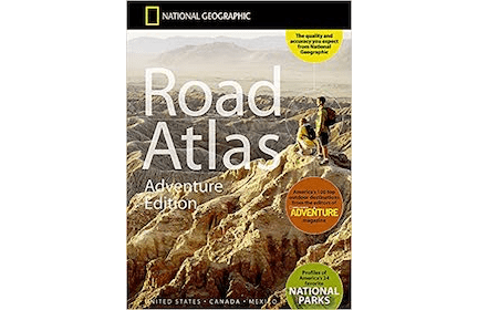
National Geographic Road Atlas 2022: Adventure Edition
Best maps:
- Rand McNally 2022 Road Atlas with Protective Vinyl Cover
- National Geographic Road Atlas 2022: Adventure Edition (choose between this or the Rand McNally atlas)
- DeLorme Atlas & Gazetteer for your state
- A custom MyTopo map of the area around your house
Other map sources:
- Benchmark state atlases
- City maps from The Map Shop
- TrakMaps for custom topographic maps in Canada
- Free topographic maps from the US Geological Survey
- Free topographic quarter quads from National Geographic
- Free custom topo maps from CalTopo
- Free maps at your local tourist center, library, etc.
Map types you should buy
For personal preparedness, there are a few core map types that make sense to focus on first:
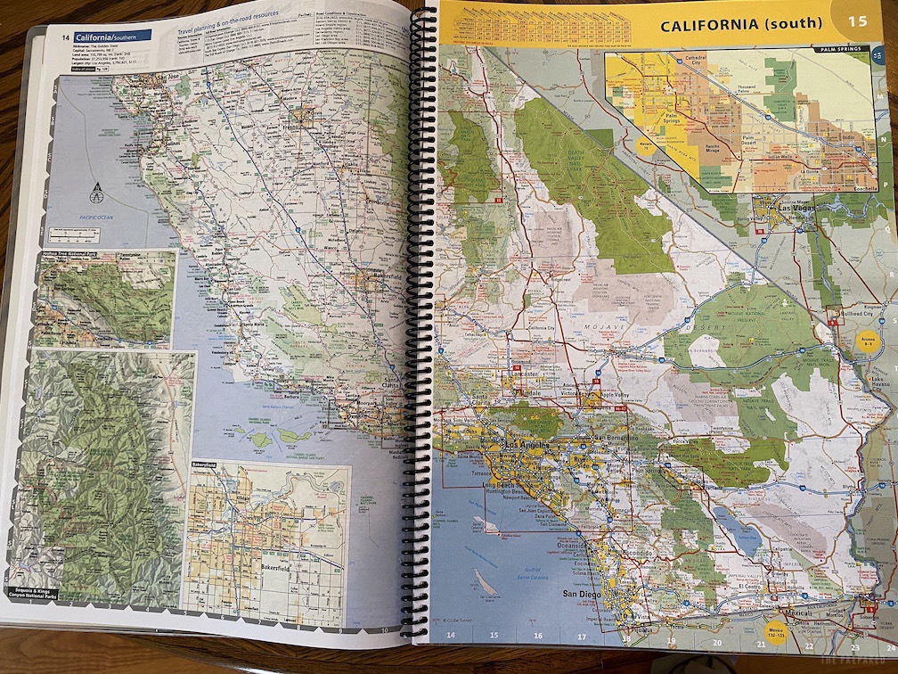
- A road atlas: These large books contain maps of the entire United States, including major metropolitan areas, and some parts of Canada and Mexico. They’re useful for cross-country driving and when you’re away from your usual neck of the woods, but they may not be very useful in remote areas and small towns.
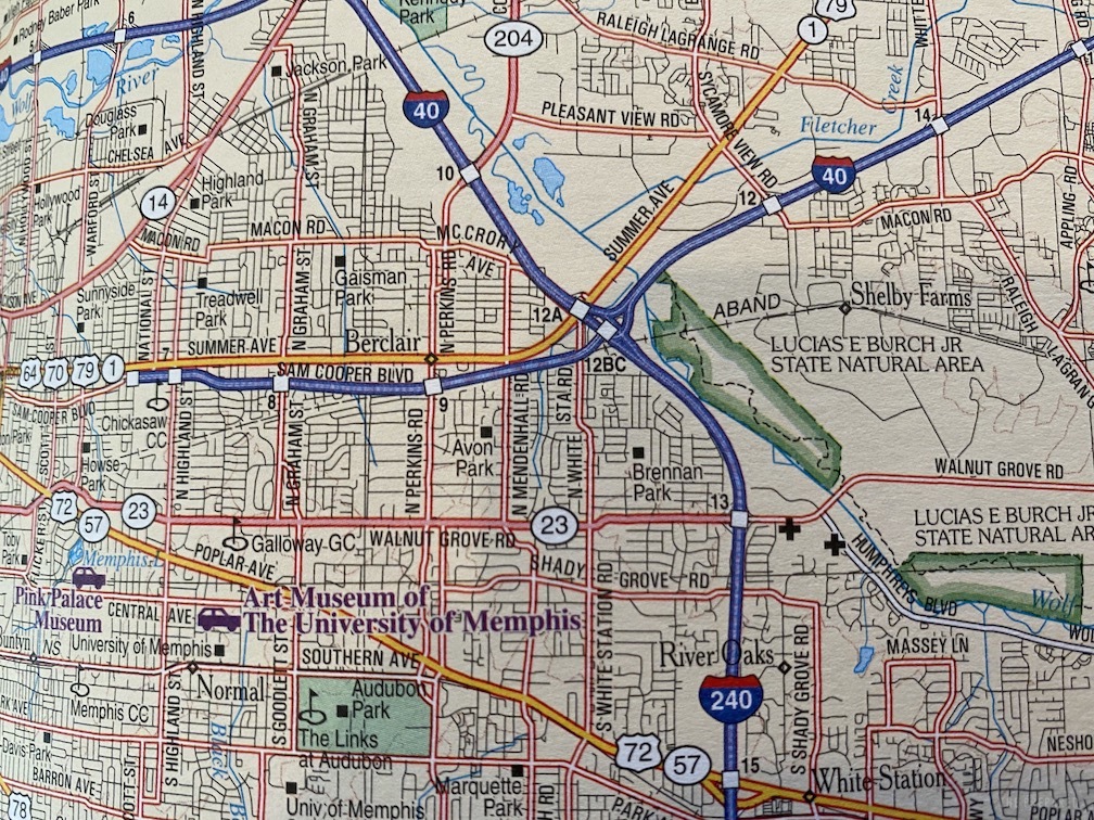
- A state atlas: Of both your state and any adjoining states if you live near a border. These will have county and city maps even for more-remote places and will show details a nationwide atlas won’t, like backroads.
- A folding topographic map: To keep in your go-bag. In a bug-out scenario, you may be on foot and have to navigate with a map and compass with a topographic map. Topographic maps usually show roads as well, but their primary purpose is showing natural features, like elevation and bodies of water.
You may also want maps of cities near you. Both national and state atlases omit street-level detail in cities, especially smaller ones. Maps of major metropolitan areas show more detail and often have detailed maps of surrounding towns (they’re produced by different publishers, The Map Shop is a good resource). If a major map publisher doesn’t offer a map for your town, you may be able to obtain one from the city or county government.
Depending on your area, there are other maps you might consider as well:
- Subway maps: If you live in a major city with a subway line, a map of those lines is nice to have.
- Nautical charts: If you live near the ocean or other big bodies of water like the Great Lakes, it wouldn’t hurt to have a nautical chart of those waters.
- Fish and game maps: Your state’s fish and wildlife department might have maps that highlight good fishing spots or maps of public hunting land.
- National parks and forests: The federal government publishes maps of national parks and forests, and you should get one if you have a national park nearby or plan to travel to one.
Understanding scale
Paper maps can’t be zoomed in and out, so cartographers have to decide what scale to draw them at. Scale is the relationship between size on the map to the size in the real world. For instance, if the scale is set so one inch equals one mile, you know that if you travel three inches on the map, you will have traveled three miles.
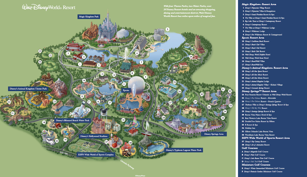
Some maps are not drawn to scale and are usually marked as such with “not to scale” or NTS. That means that while an area has been shrunk down to fit on a piece of paper, there is not a direct correlation between measurement units. These maps are fine for finding your way around Walt Disney World but are not fit for preparedness.
The scale doesn’t just define the relationship between small units on the map and large units in the real world, but it also defines how zoomed in and detailed the map is. A small-scale map shows a larger area with less detail, while a large-scale map shows a smaller area in greater detail. It’s a bit counterintuitive. Just remember large is small and the larger the number, the smaller the scale.
The United States Army actually defines three map scales:
- Small: Maps with scales of 1:1,000,000 and smaller for “general planning and strategic studies.”
- Medium: Maps larger than 1:1,000,000 but smaller than 1:75,000.
- Large: Maps of 1:75,000 and larger.
Many road atlases will show a small- or medium-scale map with large-scale callouts of important areas.
Comparison of top map brands
In the United States, there are two major producers of national atlases: Rand McNally and National Geographic. Their atlases are extremely similar. Here’s a roundup of differences:
- The National Geographic atlas is spiral bound and is printed on thicker paper than the Rand McNally, which is bound with staples.
- The National Geographic atlas has brighter map colors than the Rand McNally.
- Rand McNally has clearer exit markers, with white text on a green background just like interstate signs. National Geographic marks exit numbers with little blue numbers that are harder to see.
- The National Geographic atlas costs more than most Rand McNally atlases, but they’re both cheap.
There are other minor differences, but again, they’re both very similar.
For a state atlas, your most consistent choice is DeLorme, a division of Garmin, which produces atlases for all 50 states. The DeLorme maps double as both road atlases and topographic maps. Benchmark makes highly regarded state atlases, but they only cover a handful of mostly western states.
However, even DeLorme’s city views aren’t as detailed as you’d probably like, with smaller streets becoming a tangle of unmarked lines, which is why a city-specific map is good to have on hand.
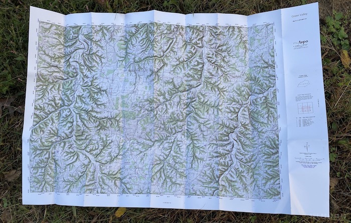
The standard for foldable topographic maps in the United States is MyTopo, which lets you order custom topographic maps of any location you want. We’ll cover how to order a custom map from MyTopo in this guide. We’ll also point you to resources to download free topographic maps.
For other maps, like individual city maps, check out The Map Shop, which sells maps and nothing but maps.
How often should you buy new maps?
Rand McNally and National Geographic update their road atlases every year. New roads are added, old roads are closed, etc., so you want the most up-to-date information. You should replace them at least once every five years or so, but ideally every year.
The DeLorme atlases are less consistent. If you look at copyright dates for the various state atlases, they range all the way from 1999 to the current year. You might check every other year or so to see if a new edition has been published.
As for topographic maps, the terrain doesn’t change very often and the government can take decades to update the data. If you have a map of the area around your home, order a new one if any major changes happen in your area. Otherwise, you should be fine replacing the map when it wears out. Always get a fresh, up-to-date map of an unknown place.
Geodetic datums
When choosing and comparing topographic maps, it’s important to understand the concept of geodetic datums. Think of these like map languages, and it’s very important to make sure that whenever you compare two maps that you’re speaking the same language.
In the simplest terms, a datum is the model of the earth on which cartographers base their maps. Here are the three most common datums used in United States maps:
- NAD27: The North American Datum of 1927, which is most commonly found on historical maps published through 2006.
- NAD83: The North American Datum of 1983, which is the more current datum.
- WGS84: Short for the World Geodetic System of 1984. This is the datum used by the Global Positioning System.
It’s very important when comparing maps to ensure that they’re using the same datum. For instance, if you’re referring to a historical map using NAD27 and another party you’re communicating with is using a NAD83 map, your coordinates may not match up at all!
NAD83 and WGS84 are often used interchangeably, and that’s fine for land navigation. However, there are slight differences that make them not interchangeable for precision applications, like land surveying.
There are new datums set to replace NAD83 in 2022, though that may be delayed. For now, NAD83/WGS84 are the most current datums in common use.
In short, you don’t need to know the technical details of datums, just know how to identify them on your map and know which one it uses.
Meet the US Geological Survey
The US Geological Survey (USGS) creates topographic maps of the entire United States. They provide free maps you can print yourself or you can order maps from them for a nominal fee. Many commercial topographic maps are based on USGS maps.
USGS maps divide the United States into quadrangles, each representing 100,000 meters (100 km), presented at 1:24,000 scale (except for some places, like Alaska and Puerto Rico, which are displayed at different scales). They’re called 7.5-minute maps because they represent 7.5 minutes of latitude and 7.5 minutes of longitude.
Searching the USGS store can bring up several types of maps for any given location, but there are two we’re concerned with:
- Historical Topographical Maps: These hand-drawn maps produced through 1992 used the NAD27 datum and contain much more detail than newer maps.
- US Topo maps: These are the maps the USGS has produced since 2009. They use the NAD83 datum. They are less detailed than historical maps because they are built from GIS databases instead of land surveys.
Due to budget cuts over the years, USGS had to abandon field collection of data, which means that while newer maps are compatible with GPS systems, they don’t reveal as much information, such as:
- Recreational trails: The USGS is working to add more of these as time goes on.
- Buildings and structures: Older maps marked public buildings like courthouses, libraries, and bridges. USGS is trying to integrate these.
- Powerlines and pipelines: Older maps had these, but newer maps probably never will due to security issues.
- Remote roads: The USGS is trying to work with other federal agencies to map these backroads.
- Public landmarks: Some are marked, such as the White House, but many are still missing.
- Recreational features like campgrounds, boat docks, swimming pools, etc.: The newer maps show a few provided by the US Forest Service and National Park Service, but the USGS says they’re not high priority.
If you have to pick one, you’re better off with the newer US Topo maps, since they use the NAD83 datum and have the most up-to-date information. However, comparing it against a historical topographic map may reveal interesting details not on the newer maps.
MyTopo sells maps based on the historical topographic maps but updates pertinent information and bases them on the NAD83 datum. We’ll cover how to obtain a custom map from them below.
How to download USGS maps
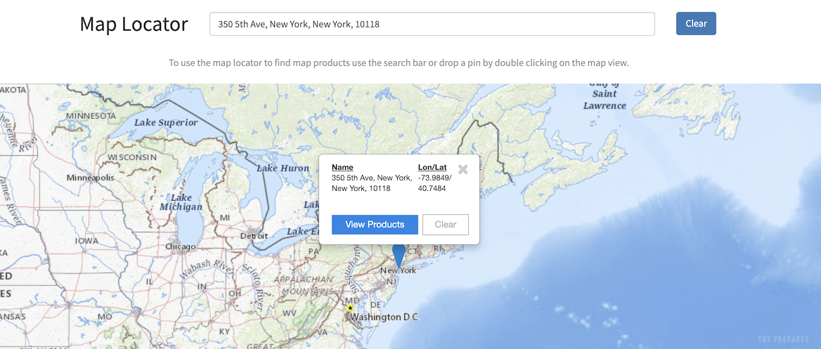
- USGS Store Map Locator
- Type an address into the Map Locator field
- Click the suggested address that appears below the search field
- Click the blue pin that appears on the map
- Click View Products
A list of available maps appears. You can click View PDF by a map listing to download a PDF of that map. The most recent maps are marked 2019.
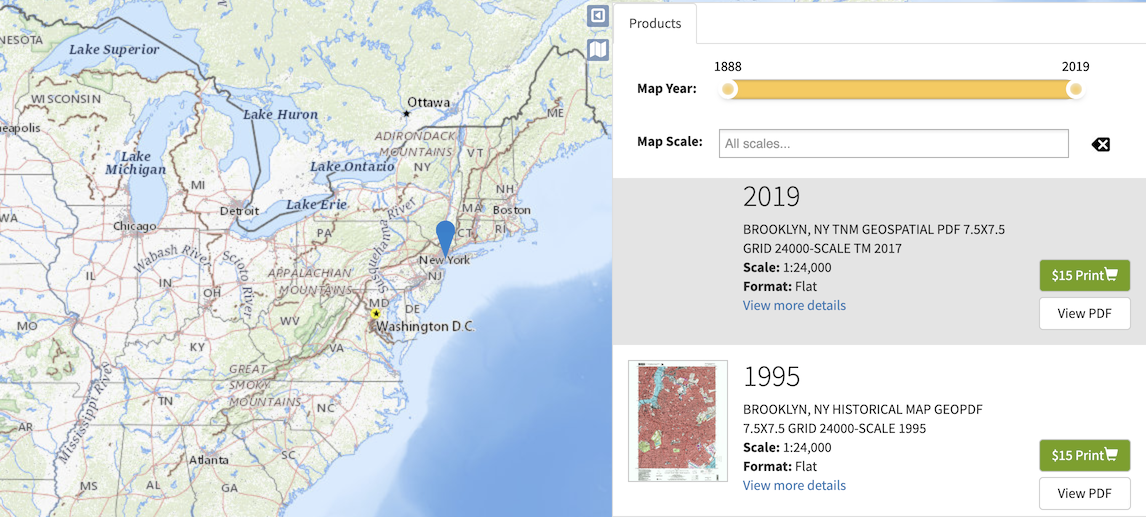
Be aware that these PDF files are very large, 100 MB or more. You can view them in any PDF reader, but slower computers may struggle with rendering the files.
Free topographic maps from National Geographic
National Geographic also offers free topographic maps, adapted from historical USGS maps and split into quarter-quads to make them easy to print. The maps may have out-of-date details, but they’re a cheap and easy option.
Zoom in on the map in the area you’re interested in mapping. Click the red square near the general area and then click the map in the pop-up, which gives you a PDF of the desired map.
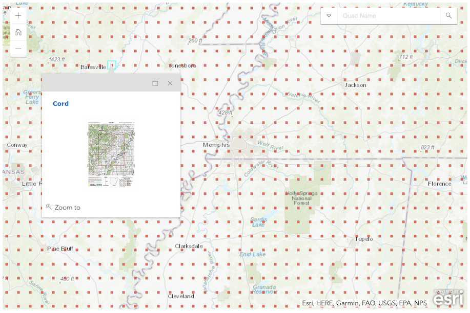
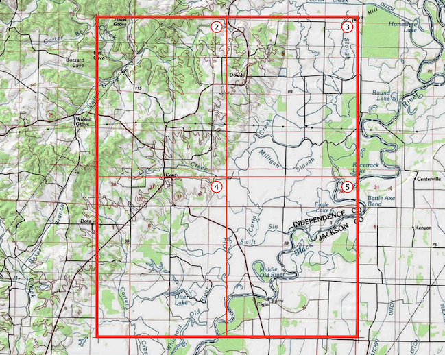
The first page is an index with a red outline around the mapped quad. Each quad is marked with a page number. Each page displays that quarter quad.
Viewing, printing, and protecting USGS and National Geographic Maps
The National Geographic maps are easy to print since National Geographic splits each quad into 8.5×11-inch quarters that you can print on Letter-sized paper on any color printer. If you have access to a color laser printer, it will produce better results. Inkjet printers tend to bleed and make details fuzzy.
You may also consider higher-quality paper. Rite in the Rain makes a waterproof copier paper that works with laser printers (not inkjets!). If you print on standard paper, you’ll want to laminate the map so it isn’t ruined by moisture. There are self-laminating sheets that don’t require a machine, but they’re glossy and thus hard to read in the sun. A better option is a laminating machine or a trip to a copy shop that can do it for you.
USGS maps are much harder to print because they’re 24×29 inches. A print shop should be able to make a print that large, but the best option, if it’s available to you, is a plotter. Unfortunately, plotters aren’t common, but if you have a university nearby with a GIS department, they probably have one and might make a print for you.
However, for maps that size, buying a map from MyTopo is probably a better and more cost-effective option. It will be printed on waterproof paper and pre-folded to fit in your go-bag.
Another option to consider with PDF maps is to carry a tablet in the field, like an iPad or a Samsung Tab. The advantage is you can carry dozens of maps with you in the field without an Internet connection. The disadvantage is that the battery must be charged and the tablet could break.
You can offset these drawbacks with a durable case, like an Otterbox, and with an external battery pack paired with a solar charger. However, you should still have at least one paper map of your area that can’t break and doesn’t require batteries.
T.Rex Arms has published a video exploring these options.
How to order a topographic map from MyTopo
You can download USGS maps for free and have them printed wherever you want, but they have drawbacks:
- The newer US Topo maps aren’t as detailed as the old ones
- The newer US Topo maps also have satellite imagery, which can obscure the contour lines when printed
- You have to find a printer that can print large maps in high resolution
- Since the maps are broken up by quadrangles, you may need several maps to cover the area around your home if it’s near an edge
The National Geographic maps are free and easy to print, but are out of date and only show a quarter of a quad.
MyTopo offers custom USGS maps for a reasonable price, about $20 after shipping. Here are some of the advantages of buying a map from MyTopo:
- They’re based on the more-detailed USGS historical maps but are updated with recent information, like roads
- They can be customized to be centered on an address, like your home
- They can be ordered with custom options like property lines and shaded contour relief
- They can be ordered to use the NAD83 datum instead of the older NAD27 datum
- They’re printed on waterproof, tear-resistant paper
Update: As of Feb. 2022 the only way to buy a custom map from MyTopo is to call 877-587-9004. Once they finish the site redesign the following instructions should work again.
We’re not sponsored by MyTopo, it’s just a great resource for topographic maps that can fit in your go-bag. However, it offers an overwhelming number of options, so here’s how to order a useful map:
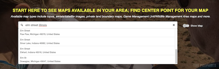
- Visit MyTopo
- Click Search Maps Now
- Enter an address in the search field, like your home address
- Suggested addresses are listed under the search field. Click the one you want.

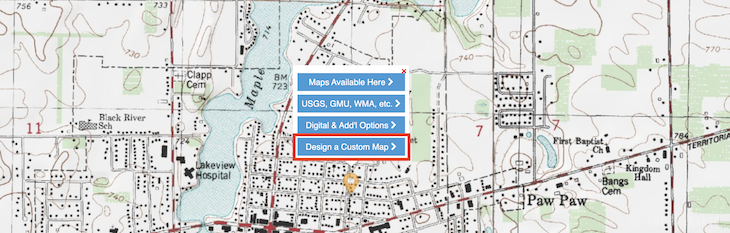
- A map appears with a pin mark over the selected address. Click Design a Custom Map.

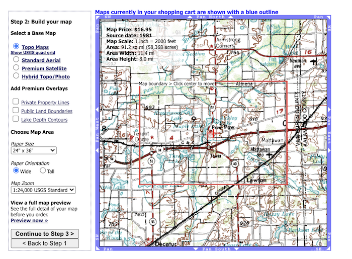
You’re presented with the map builder interface. On the preview map, a red box outlines the area that will be on your printed map. The default scale (for maps in the United States) is 1:24,000, but you can change that if you want. You can also customize the paper size or add things like private property lines and public land boundaries, but they will increase the cost of the map. Most people can stick with the defaults.

- Click Continue to Step 3
- You’re presented with printing options. For a map to stick in your go-bag, select Waterproof “Outdoor” Map and Folded.
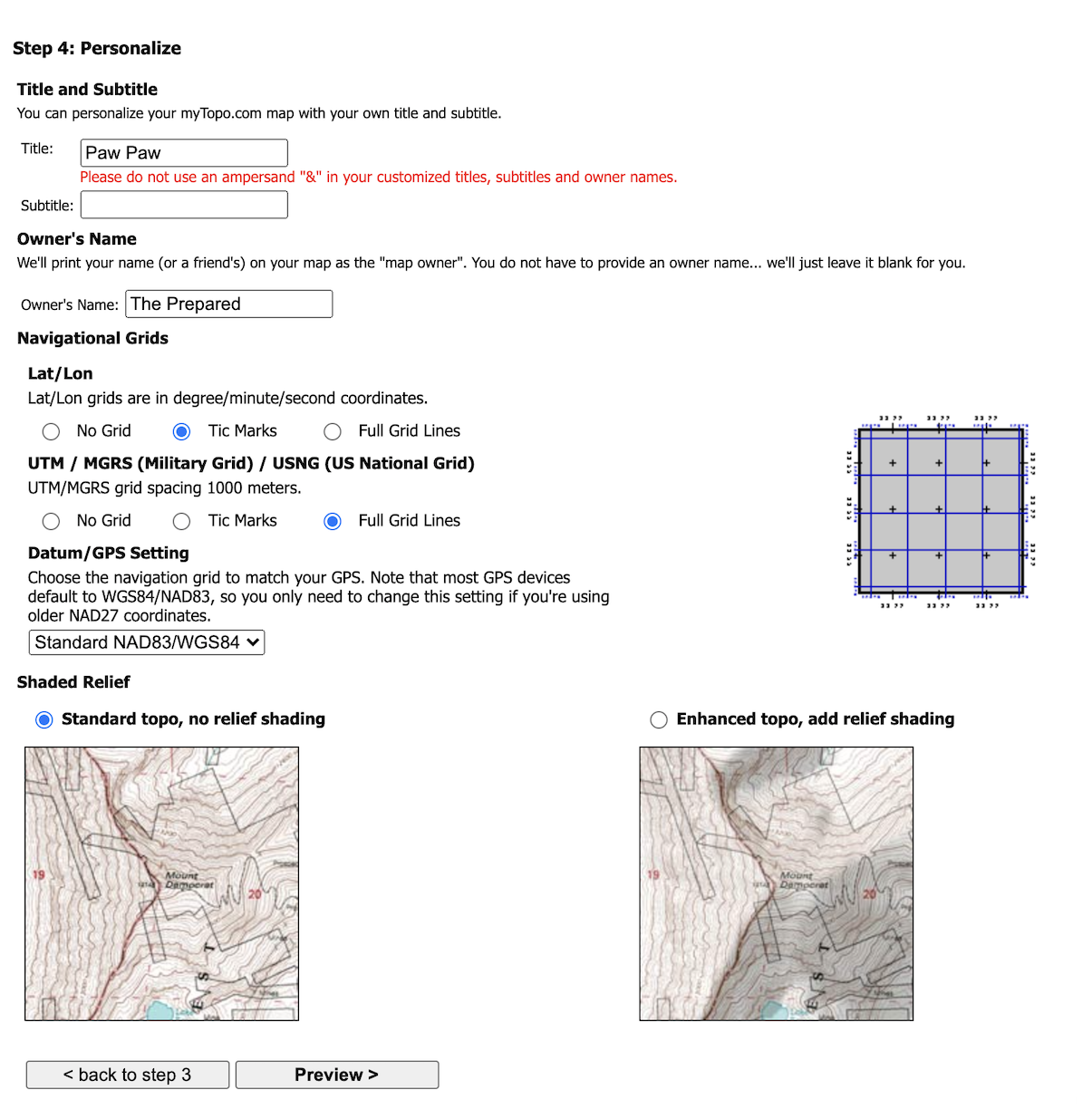
- Click Continue to Step 4.
- Enter a custom title, subtitle, and owner name if you want.
- For Lat/Lon, select Tic Marks. That will note latitude and longitude coordinates on the outside of the map but won’t add extra lines to the map itself. The more lines on the map, the harder it will be to read.
- For UTM / MGRS / USNG, select Full Grid Lines. We want those gridlines on the map for navigation.
- Under Datum, leave it at NAD83/WGS84.
- Under Shaded Relief, select either no relief shading or add relief shading. The choice is your personal preference, but relief shading can make steep elevation changes easier to see at a glance. Pick one, preview it, and then preview the other option to see what you like best. Some recommend against shaded relief because it can play tricks with your eyes.

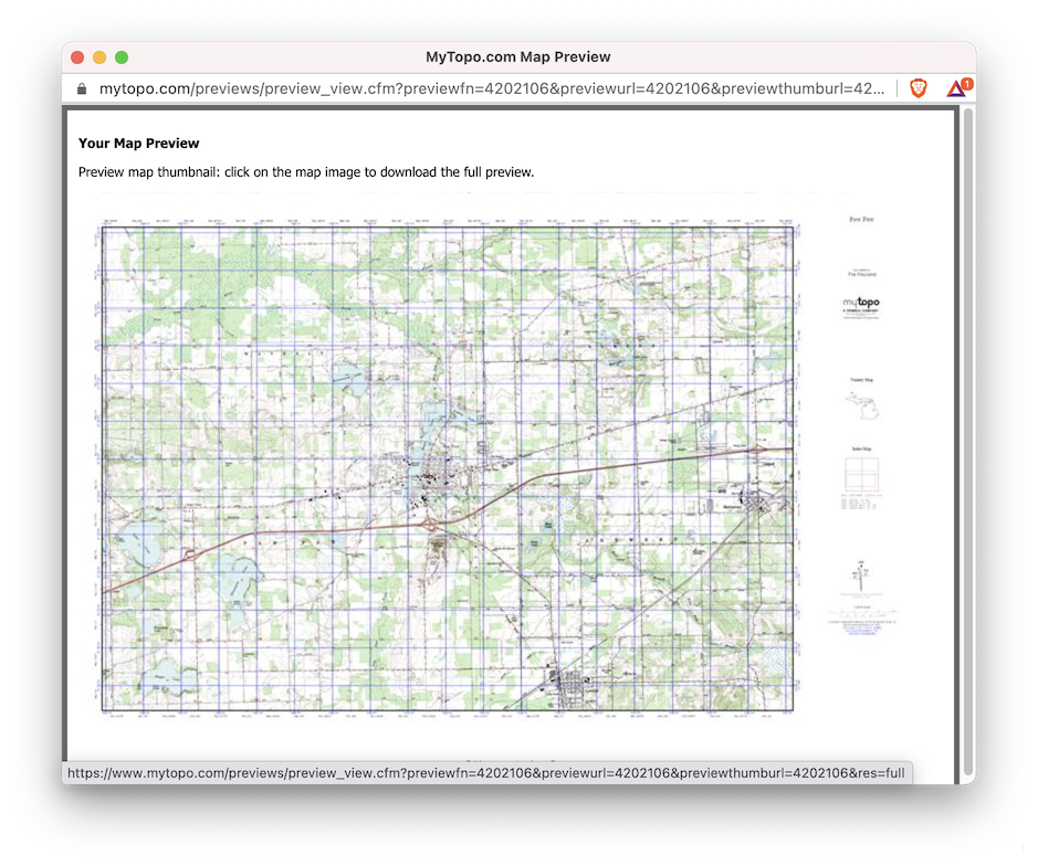
- Click Preview and then “View a preview of your printed map,” which opens a new window that generates a preview of the map.
- After the map preview renders, click it to see a full-size preview. Even the full-size preview is a little blurry (because they don’t want you printing their map for free). If you’re satisfied with how it turned out, close the preview window.

- If you want to edit the map, return to the first window and click Edit Map. Unfortunately, that takes you back to the second step and you’ll have to click through again to adjust options.
- If you’re satisfied with the map, click Add to Cart.
- Click Begin Checkout and conclude the checkout process.