The world has become too dependent on GPS, sometimes in surprising ways that have more to do with precise timekeeping than simple location.
So it’s helpful to understand what kinds of threats can affect GPS, and how long that system would continue to work for people on the ground in a collapse situation (eg. The Walking Dead).
We reached out to various experts to learn more, including the press office of the US Air Force (they manage GPS) who understandably didn’t want to go into too much detail — and now we’re on yet another watchlist 🙁
Summary:
- The GPS network needs constant tweaking via uplinks from the ground.
- These daily updates often make small microsecond adjustments to the clocks used in the system to deal with things like orbital drift and how time moves differently in orbit (thanks general relativity!) Those small adjustments make a big difference in space.
- If that ground-based maintenance stops, problems will start to pop up within hours or days and GPS will become effectively useless in roughly a year.
- Location accuracy is estimated to be off by half a kilometer (a third of a mile) within two weeks, for example, and off by 10 km (over six miles) in six months.
- Besides the ground going dark, other major threats are malicious attacks by countries like Russia and Iran — GPS spoofing is surprisingly easy — or ‘space weather’ events like solar flares.
More: Guide to EMP threats and learn how to use a map and compass
How GPS works
While work on GPS started in the 1970s, it didn’t become fully operational until 1993. Even then, civilians weren’t allowed access to the full powers of GPS until 2000.
GPS is a marvel of engineering, controlled by the US military and operated by the US Space Force — though we reached the Air Force when we called to inquire about GPS, probably because the Space Force is brand new and still transitioning things over.
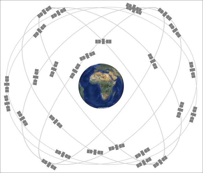
The network consists of 31 satellites of various ages orbiting the Earth twice a day at an altitude of approximately 12,000 miles.
As I’ve learned from chasing satellites with a ham radio, a single satellite isn’t reachable from one place for very long, so having a sky full of them makes it so one is always in reach.
One of the keys to GPS is that each satellite has an atomic clock for precise timekeeping. The satellites synchronize time with each other and are regularly corrected by ground control stations. Precision is a must — even small drifts in the clocks cause big problems.
Those satellites are managed by 16 ground control stations scattered around the planet: six operated by the US Air Force and ten operated by the National Geospatial-Intelligence Agency. The Master Control Station is located at Schriever Air Force Base in Colorado Springs, Colorado.
The ground stations are positioned so each satellite is seen from at least three monitor stations at any given time. Three is an important number for triangulation, which is how GPS figures out your location when combined with super-accurate timestamps.
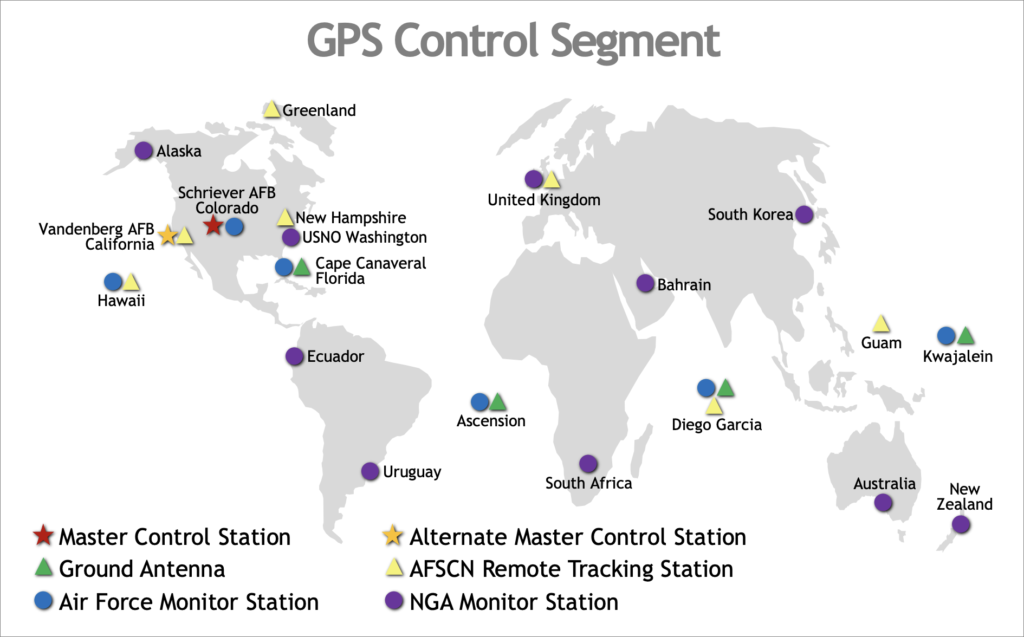
Those ground control stations are critical for monitoring the health of the satellites and correcting time and orbit as needed. Additionally, there are four antennas that regularly update the satellite clocks, as Scientific American explains:
The current GPS is a network of 31 satellites known as Navstar, operated by space squadrons of the U.S. Air Force. To maintain accuracy, the squadrons deliver Coordinated Universal Time to the satellites, via a network of four antennas from Cape Canaveral to Kwajalein Atoll, up to three times a day as the satellites fly overhead. Thanks to each satellite’s payload of atomic clocks, the time they keep is accurate to under 40 nanoseconds—after adjustments are made for general relativity, which makes the satellites’ clocks tick about 45 microseconds a day faster than clocks on Earth, and special relativity, which makes them tick seven microseconds slower.
There are alternatives, like Russia’s GLONASS, but GPS does not interoperate with it, and given current US/Russian relations, that is unlikely to happen in the foreseeable future. Europe has its own Galileo system and China has the BeiDou constellation of positioning satellites.

What happens when GPS fails
The list of ways GPS has embedded itself into daily life is endless, and entire industries would grind to a halt without it. Despite 20 years of efforts, there is still no backup for GPS. Congressmen and other watchdogs are still pounding the proverbial pulpit to get a backup in place.
In January of 2016, the Air Force accidentally uploaded the incorrect time while decommissioning a satellite. Despite being only off by 13 microseconds, it caused days of problems around the world. Global telecommunications networks failed, first-responder radio equipment stopped working in parts of the United States and Canada, BBC digital radio was out for two days, and there were even problems detected in electrical grids. All it took was an error of 13 microseconds to do all that.
Time-keeping and synchronization has become an essential function of GPS. GPS is used to keep cellular towers in sync, timestamp financial transactions, calibrate Doppler radar systems, synchronize movie cameras, synchronize computer networks, and timestamp seismic monitors. It’s also used by ham radio operators for JS8Call, a popular digital mode for preppers.
Taxi and ride-sharing services depend on GPS to track cars. Emergency services use GPS to track first-responder vehicles and direct them to emergency calls. Cranes at shipping ports depend on GPS to unload ships — and as we’ve all learned from Covid, our just-in-time inventory system is incredibly sensitive to shocks.
GCN, which covers government IT infrastructure, published a troubling report claiming that critical infrastructure is not prepared for GPS disruption. A UK Government report from 2017 estimated that a five-day GPS outage would cost the UK over $7 billion USD.
Jamming or spoofing signals is like holding a magnet to a compass
The number one threat to GPS is jamming or spoofing. Because GPS was not designed with security in mind and the signal from GPS satellites is so weak, it’s very easy for terrestrial stations to interfere with those signals, and it’s happened multiple times over the years.
Some examples:
- December 2011: Iran used GPS spoofing to capture an American UAV.
- Summer 2013: A University of Texas research team hijacked a yacht by spoofing a GPS signal.
- August 5, 2016: Cathay Pacific Flight 905 lost GPS while heading from Hong Kong to Manila. In July and August of 2016, the International Civil Aviation Organization received more than 50 reports of GPS interference at the Manila airport.
- June 2019: A passenger aircraft in Idaho nearly crashed into a mountain. Malicious GPS interference was cited as the likely cause.
- June 2019: GPS signals at Israel’s Ben Gurion airport repeatedly failed. Israel blamed Russia for a spoofing attack that sent phony location data to pilots. Russia denied any involvement, but a 2019 study conducted by C4ADS documented nearly 10,000 incidents of Russian GPS spoofing.
The 1997 James Bond movie Tomorrow Never Dies was based on this idea:
It’s so easy to spoof GPS data that you can do it yourself with a software-defined radio called HackHF. Here’s a YouTube video demonstrating how it works:
Some kids have been known to use HackRF to cheat at the location-based game Pokemon Go. It’s sadly that easy.
Solar storms can disrupt GPS
An electromagnetic pulse can come from nuclear weapons or solar flares. In this case, EMP energy released by the sun in a coronal mass ejection can interfere with GPS satellites — radio signals are especially sensitive to space weather, as any General-class ham radio operator knows.
The sun goes through cycles of sunspot activity, called the solar cycle. We’re currently coming out of a solar minimum, but a few years ago during the last solar maximum, there were concerns that GPS could be interrupted. As NASA wrote in 2013: “Solar flares can temporarily alter the upper atmosphere creating disruptions with signal transmission from, say, a GPS satellite to Earth causing it to be off by many yards.”
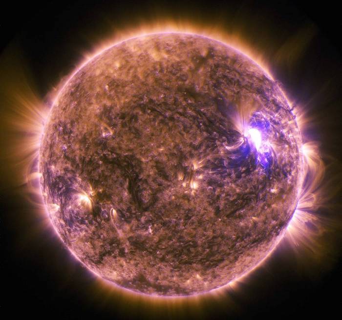
Indeed, a large solar flare nearly disrupted GPS in 2017. “Harmful radiation from a flare cannot pass through Earth’s atmosphere to physically affect humans on the ground, however — when intense enough — they can disturb the atmosphere in the layer where GPS and communications signals travel,” NASA said in a statement.
Thankfully, these concerns have so far been theoretical rather than actual, but a time could come when a large solar flare or a dreaded coronal mass ejection could disrupt GPS communications.
More: Your car will probably be fine after an EMP
Abandoned ground stations
Let’s say the dead rise from their graves to eat the brains of the living and, as a result, all of the 16 ground control stations were abandoned. How long would GPS continue to work?

The good news is that GPS satellites physically last a long time, often much longer than expected. Garmin, producer of many GPS products, says that each satellite is built to last ten years. But USA-132 was launched in 1997 and is still in service!
The bad news is that without constant correction from ground control, the satellites would drift out of sync and become useless. Dr. Lewis Dartnell, an astrobiologist at the University of Westminster, said in his 2014 book The Knowledge: How to Rebuild Civilization in the Aftermath of a Cataclysm:
While fuel stocks and cannibalized parts will keep cars, planes, and boats going for a while, the modern GPS navigation devices we have become so reliant upon will malfunction surprisingly quickly after satellites lose the regular uplink from their command center. Positional accuracy will drop to about half a kilometer within two weeks of the Fall and around 10 kilometers within six months, and the system will be utterly useless within just a few years as the satellites drift out of their precisely coordinated orbits.
I emailed Dr. Dartnell to ask if anything has changed since the book was published, and he informed me that no, it’s pretty much the same as it was years ago.
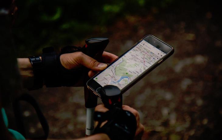
In a SHTF event, you could rely on GPS perhaps temporarily, but you would need to use landmarks to regularly check the system’s accuracy and make adjustments as needed.
You are reporting the comment """ by on