12

Triple Quake in NZ interesting point of note.

I’m posting this as an FYI because of one part of the news story that is of direct interest to us. I’ve posted the text in BOLD Italics below.

New Zealand earthquakes: Tsunami warnings lifted after evacuations
Published
3 hours ago

Three earthquakes, including one of the strongest ever to hit the region, struck off the coast of New Zealand on Friday, triggering tsunami warnings that have now been stood down.
Thousands were evacuated from some coastal areas of the North Island after the third, 8.1-magnitude quake struck.
There were reports of traffic gridlock as people tried to reach higher ground.
The national tsunami warning was lifted at 15:43 (02:43 GMT), some 13 hours after the first quake.
Some wave surges hit parts of the coast but, by Friday afternoon, authorities said the largest waves had passed. Residents were told they could return home but were warned to stay off beaches.

media captionNew Zealand: “What happens if there is another earthquake?”
The South Pacific archipelagos of New Caledonia and Vanuatu have been warned to prepare for dangerous waves.
Their coasts could see wave surges as high as 3m (10ft), while parts of South America – including Peru, Ecuador and Chile – were warned they could see 1m waves reaching their coasts.
The Hawaii-based Pacific Tsunami Warning Center said “tsunami waves have been observed”, but as yet no damage had been reported.
‘Bumper to bumper’ traffic
New Zealand Prime Minister Jacinda Ardern posted on Instagram: “Hope everyone is ok out there.”
The three earthquakes, all above 7.0 magnitude, came during the early hours of Friday.
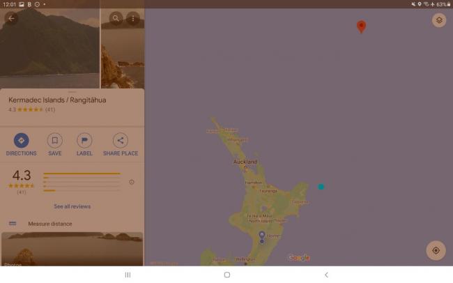
The last, at 8.1, struck at around 08:30 near the uninhabited Kermadec Islands, 1,000 km (621 miles) north-east of New Zealand.
While earlier tsunami warnings had been called off, the third quake prompted the National Emergency Management Agency to send out a new alert and tsunami sirens sounded in some areas.

The agency told people near the coast in several areas to move immediately to high ground or get inland as far as possible.
It said “strong and unusual currents and unpredictable surges” with tsunami activity continuing for several hours.
Local media reported gridlock in towns such as Whangarei and Whakatane as people tried to flee their homes, schools and workplaces.
In nearby Ohope town, resident Leslie Peake was quoted by the New Zealand Herald as saying the traffic was “bumper to bumper” with “huge queues of people evacuating”.
New Zealand’s civil defence department advised people to walk or cycle to avoid getting caught in traffic
Meanwhile local media posted footage of waves rolling into Tokomaru Bay.

29

  • Comments (29)

    • 7

      Hi, I am from New Zealand and my mother was one who did evacuate. She was higher than some of the evacuation points, but did so to be on the safe side. It was interesting discussing things with her after she went back home. 

      She left in a panic. This despite the fact that we have been discussing bug out bags for the last week (I am helping her with it), she left without the stuff she had in her bag (she didn’t grab the bag.), and didn’t grab any extras like her laptop, food or cash. Takeout of this is the need for mental preparation. 

      She had no choice but to go via car. Her husband has limited mobility, and the friend they help is blind. They were not happy about going and they grumbled and complained. This had a very negative effect on the mood and was mentally draining. My suggestion was to make sure that she has really chewy toffee (glue their teeth together). Its something to think about when you are the only one concerned enough to get an emergency kit together.

      Just for reference – here is a map. My place is pinpointed in blue. I only felt the first earthquake, at 2.30am,  which was 7.1 magnitude is shown in turquoise,  the 8.1 earthquake is pinpointed in red was at 8.28am.

      20210306_003053

      • 6

        LBV – Glad to hear you and family are ok. Your points about Mom’s reaction underscore the need for drills and practice.

        The toffee comment was hilarious. I will remember that coping strategy lol. I  can see how it would distract and bring down the mood.

        On a serious note, I wonder if redirecting someone who is grumbling could work? It also raises the issue of how to cope with someone who may panic, etc.

        It is definitely a time when a “hive mind” is needed. 

      • 5

        LBV hows about making a bag of essential kit for you mum and leaving it the the boot / trunk of her car??

      • 5

        We were just discussing that. She is sorting out what she has and adding a few things and putting in the car. She will get me to buy freeze dried food and send them up.  I am suggesting things that she can add from her end as well.

    • 6

      Bill, This event underscores your photos/comments on the other thread. If one can leave before, get out. Better to leave early and find out it is all clear from a safe location than to stay and have your final thoughts be “Wow, Bill was right. I should have left sooner.”

      Gridlock is another reason bicycles are a good item to have on hand (and on the bicycle rack of a vehicle in case the vehicle breaks down).

      • 6

        What scares me is apparently how the PRIMARY evac routes to avoid a tsunami became quickly gridlocked, it sound like for many people fleeing is not viable and relying on government guidance is NOT the best option. Perhaps some Kiwis could find ALTERNATIVE routes to high ground, or seek safety in tower blocks ( if they are not damaged by the quakes)    if I was a Kiwi I dont think I would blindly follow government advice and seek alternatives, that must be better than sitting in gridlocked traffic with 10 meters of water baring down .

      • 6

        Primary evac routes clog because everyone is directed there. Alternate routes/mode of travel might not work for every situation.

        I wonder if a well researched overland route might work for certain areas/situations? It would have be to a certain route or one could land in trouble quickly if it is only theoretical and not tried and true.

        It could be worthwhile to study the appropriate types of maps for one’s area, identify potential disasters that could invoke evacuation, and then look for reliable, all season evacuation options that would safely avoid gridlock, including alternate modes of transport.

        A bicycle might be too slow in some cases. A dirt bike might work if gridlock and getting out of the area rapidly is the main concern.

        Eventually the bike will run out of fuel, but an extra can of gas mounted on the dirt bike would make it possible to calculate how far away one could get. It can handle difficult or overland terrain also.

        Another point, I have wondered if some people are late leaving because of job demands or employers who won’t let them leave until the last minute?

      • 4

        I wonder if LOW geared electric bicycles could be used to gain altitude, or perhaps micro motorbikes??

    • 7

      Thanks for sharing the great article and for tying it directly to what we can learn from the situation Bill! 

      I would take this as a learning experience if I was in the area and try and figure out where the gridlock was, and try and figure out where there were any openings that I can use for the next disaster. I’m sure most people will just go the same route they went last time. 

      LBV – I’m glad you and your mother were safe. Thanks for sharing what you both learned from this. It was very informative and educational. Is there anything you are going to do differently with your preps and plans after this situation?

      • 8

        I truly do wish with all my heart that my fellow preppers and survivalists would spend a bit more time studying maps of their local areas, AND doing more reconnaissance trips.  Escape routes, High ground, Low Ground, Pinch Points, Flood Zones, Cycle paths, Tow Paths, Bridle Ways, , Farm tracks, Old Rail Lines etc   Anything that could / may / should give them an advantage.

      • 4

        Just to reinforce my comments about finding ALTERATIVE escape routes and places of safety. the image below I am told is of an approved escape route to avoid these dreadful fire storms that hit the US and Oz last year.

        Even our governments and NGOs can get it tragically wrong sometimes, so  it STILL comes down to US to plan and prep and react as WE see fit.

        california wild fire 2019

      • 9

        Well said.  I have looked at all possible routes between my work & the farm.  As I do, I check out all water sources on that route in case I have to walk home.  If I can’t see well from the road or have some other concern, Google Maps is an incredible resource.  I use that to map other possible cross country routes that might shorten my trip.

      • 7

        That is a smart idea to keep an eye for possible water sources along your route. I’ll have to do that too. 

        I think i’ll also try to look for possible shelters, natural and man made, food resources, and wood for fires sources. Mark them out on my map. And maybe each day while i’m driving that route to work, i’ll mentally point it out to myself each time I pass that so that it becomes second nature that there is a resource there.

      • 4

        Dont forget that many maps are printed only on one side, this makes them ideal for recording notes and findings on the reverse of useful information found in the area the map covers.

      • 4

        What advice and tips do you have for us on making an evac route? 

        I’ve tried looking at things like Google Maps before to plan a route, but had trouble estimating elevation. I guess I could use  a topo map, or just get up off my lazy butt and drive around and see it in person. 

        I’m planning on having my bike on the bike rack of my car. If my car gets stuck, runs out of fuel, or grid locked like you mentioned above, I could pull off the bike and keep going. But hills and things are something I’m concerned about while running off of human power.

      • 5

        No easy way unfortunately use GE and Topo maps to identify points of interest, then go and take a look.   You could consider an electric bike or monkey bike to help you get about.

      • 7

        I would think most people wouldn’t know how to read a topo map and get much use from it.  It is not all that difficult but does take some understanding of scale.  I learned years ago at the Mississippi State School of Forestry.  We took surveying classes and had to make our own Topo maps.

      • 4

        Elevation ASL and local topography are hugely significant in resulting Tsunami damage.  If you are high enough (with reference to sea level, of course), you may be fine right where you are.  At th same height, in a narrow canyon, you may be exposed to hazard.

        i am in southern California, and tsunamis have wrecked havoc in the past and will do so in the future.  I am 500 ASL overlooking a broad plain, so I am pretty secure.

        In Alaska, there are reports of tsunami damage at over 1000 ASL, but confined to narrow canyons which funneled the waters upward.  

        You can evaluate your situation, judge the risk, and plan ahead for the event.  With tsunamis, you will have some advance warning, ranging from a few minutes to hours.

        The important thing is to get high! (ASL, of course)….

      • 4

        As I live in the middle of the island, tsunami is not an issue I have needed to deal with with my immediate prep. However, if I travel to any .locations near the coast it is something I need to consider. For me that may mean a fully equipped bug out bag in my car. 

        I know in Wellington they have evac marking blue lines that show the areas you need to get to. There are events in NZ like ‘The Big Shakeout’ where people are encouraged to enact responding to a big quake. One of the activities is walking to a safe location to avoid tsunami. 

        The biggest issue in NZ is the attitude which is ‘She’ll be right ‘. On the news it said only about 15% of the population have an emergency kit.  This is after the Christchurch (6.3) and Kaikoura (7.8) earthquakes. When I was told about the potential for an 8.9 East Coast, I have had some friends say that you can’t prepare for that. Official information in NZ says to prepare three days, but the reality is that you are on your own for 7 days. My friends say ‘we know where to come’ – to my place.

    • 7

      Sometimes those tasked with caring for us simply do not learn

      https://abc7.com/business/long-beach-hospital-which-sits-on-active-quake-fault-line-to-close/3181595/

      https://ottawacitizen.com/news/local-news/new-hospital-to-be-built-on-fault-line-but-experts-arent-worried

      When ever MAN thinks he can beat mother NATURE  man normally ends up regretting his decision.

    • 5

      Bill, Only a couple of hours ago I posted a comment on different thread about evacs being a neglected matter.  

      Besides the recent historical examples, I also rely on “comparative studies” … what do “they” do over in ____ ?, Why was everyone saved at ___?.

      Here, $$$ governs.  Anyone can live anywhere.  In emergencies, there’s a prepper term applicable to this: YOYO – You’re On Your Own”. 

      Here, when there’s official evacuations, prior to this announcement, peripheral areas to evac route are closed off by area Sheriff’s offices. This particular area, near so many Federal and military facilities, … the important ones are “hardened” … means we also have terrorist events.  This area is now a garrison state and don’t even think it represents badness.  

      Private citizens in the major metro areas must leave early – very early.

      • 4

        Bob and Bill –

        First, Bill – Thank you for starting this thread. Had I not seen it and gotten curious about evacuation routes and maps for our area, I wouldn’t have found out was a SNAFU we have here. 

        Yep, we’re YOYO here. I checked today for evacuation routes and maps for my area. I can get maps, topo maps, all kinds of maps. No evacuation routes.

        That led me to much fun today with our provincial website and how evacuation works here. It is a “guideline” and to be applied as anyone may see fit as indicated in the second page foreward.

        Also on page 15 bottom 4.9 Evacuation Routes: There are none. To be decided.

        Manitoba emergency measures evacuation

        You would have to understand the workings of our municipality to realize how bad that news is.

        We have small town council members who are just not equipped to handle anything like this. You need people trained and skilled in this sort of crisis administration.

        There are many local municipalities and if they are all doing different things during a disaster which could affect most or all of our province, I can’t imagine what a nightmare this could be.

        Maybe they think the disaster will behave itself and just remain obediently in one municipality.

        The logistics of the evacuation if these efforts aren’t coordinated are unthinkable. Where do they plan to send us to if we have to evacuate?

        How much time is this all going to take if it is a rapid disaster and evacuation must be deployed quickly?

        We have had tornados including an F5 in this province, serious flooding, chemical spills, fires and more. What if we had an act of terrorism? Biowarfare?

        There is no excuse for this. In the USA you have great evacuation routes marked. You’re organized and you have people who are responsible for how to handle a disaster. 

        What if a tourist was here during a disaster and had to evacuate? They don’t know the roads. If the main evacuation routes aren’t marked, then that could spell disaster for them.

        I really thought this would function under Provincial orders, like the health dept during the pandemic. I didn’t expect Federal involvement, but this is absurd.

        My husband said of this news “British Columbia has evacuation routes posted everywhere on the highways and communities. Do you remember the signs?”

        Oh yeah, I remember the signs. There aren’t any here.

      • 7

        Less than 5 years ago, we here in the equivilants of small town Manitoba, involved local municipalities doing different things. County A sets up an emergency shelter – well prepared, well stocked,.. a medical clinic with a nurse and EMT are part of set-up along with a co-located emergency animal shelter for pets and vet care for service animals. Counties B,C,D and E do not set up shelters.  Their funds were used to send county employees to important conferences (a/k/a/ vacations/holidays). It is not allowed to restrict who can seek safe haven in an emergency shelter.

        There is a relatively new term in the US emergency management lexicon: political sensitivities.

        True, major evacuation routes are marked with signs. Organized ? 

      • 5

        Understood, Bob. Evac signs do not an organized effort make. Thank you.

      • 5

        Remember peretaining to Evac Routes etc they are G.U.I.D.E.L.I.N.E.S  Not RULES or LAWS.   As my American cousins point out “WTSHTF YOYO”

        ALL Civil Defence goes back to the 50s and 60s and lets never forget that from day one back then our collective governments spent BILLIONS ensuring their continuity, but also decided that most of the public was left to fend for itself, it is EXACTLY why prepping and survivalism came into being.   Escape routes are often comprimises and not always the BEST option for us..

      • 4

        Bill, I understand. If the SHTF, my husband and I would be the last persons to head with the masses.

        I just wish they had put some effort into giving people who don’t understand any of it and don’t prep, a fighting chance. 

        Prepping and survival should be part of school curriculums.

    • 6

      An article reviewing evacuation and the problems. Interesting to note the comment “He said the first people to arrive came well prepared, but those coming now were coming with nothing.”

      https://www.nzherald.co.nz/nz/tsunami-warning-gridlock-as-people-flee-to-higher-ground-following-earthquakes

      • 5

        LBV, Just glanced at linked article.  Engineers and emergency managers know the basics such as number of vehicles on a road for routine speed flows, number of tow trucks needed per thousand of vehicles, number of police vehicles needed for public safety and security, number of ambulances,… The political establishment does also. It costs a fortune to properly prepare.

        The public does not want to change their lifestyles. 

      • 3

        NAILED IT   “He said the first people to arrive came well prepared, but those coming now were coming with nothing.”  

        This is why I keep harping on about constantly monitoring media and emergency warning systems. In the UK most of our radio station can and often do TWO things.   (1) Automatically increase volume when TRAFFIC or WEATHER EMERGENCIES are declared, and (2) Automatically switch stations to any station (FM bands only) making traffic or weather or emergency warnings.   So we DONT have to ONLY listen news broadcasts we can listen to entertainment news knowing the radio will jump to the emergency or weather reports as they start.

        Forewarned is Forearmed

        Early Bird Catches the Worm