The digital world changes quickly, so share your thoughts on which apps should or shouldn’t be recommended!
Tip: Watch out for what permissions you grant to many of these free apps. If a free compass app is asking for permission to access your contacts and calendar, maybe try another one that doesn’t request any permissions. Fight back against developers taking more access than they need!
Emergency alert apps
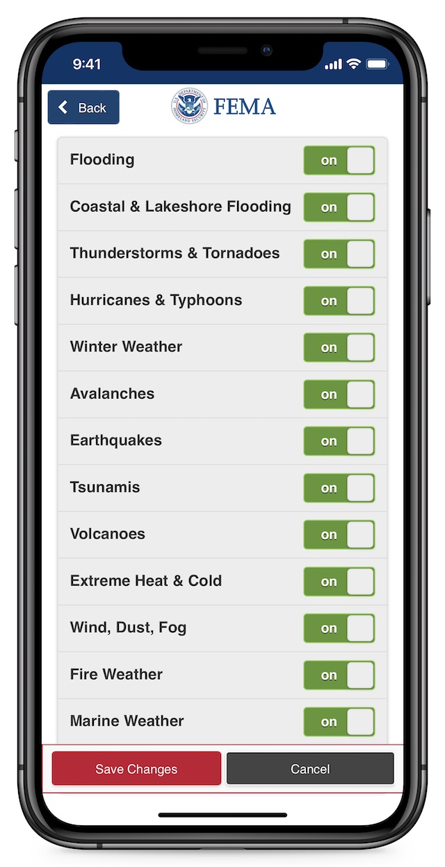
- FEMA (iOS, Android, free) provides real-time alerts based on locations you define, warning you of everything from thunderstorms to volcanoes. Helps locate nearby FEMA shelters. You can apply for disaster recovery assistance straight from the app.

The FEMA app has alerts for pretty much every disaster. - Citizen (iOS, Android, free) is a crowdsourced incident alert system. If you or others see something such as a fire, police interaction, or terrorist attack, spread the word or even livestream video to notify other app users.
- Neighbors by Ring (iOS, Android, free) allows you to upload video and other notifications from a Ring doorbell to alert neighbors of local safety issues like the Citizen app. You do not need to have a Ring doorbell to use this app.
Communication apps
- Signal (iOS, Android, free) is an all-in-one app for text, voice, and video. SMS text messages (ie. normal/classic texting) are terribly insecure, and most other apps like Telegram and WhatsApp aren’t much better. Signal is the trusted, encrypted king endorsed by security experts like Bruce Schneier and Edward Snowden.
- Google Translate (iOS, Android, free) has the most languages and features of any free translation app. Can do basic text-to-text, text-to-speech, and speech-to-text, and can use the camera to translate printed words in the real world. Can work without an internet connection.
- Police Scanner Radio & Fire (iOS, Android, free) Listen in on over 7,000 police, fire, EMS, amateur radio, and other stations. Receive alerts when an unusually large number of people are listening to a station, which could mean something big is happening. The $3 paid version includes more features, such as the ability to record stations.
- Zello Walkie Talkie (iOS, Android, free) turns your phone into an internet-based walkie-talkie to send short burst messages to others using the app. Keep in contact with your family or prepping group by sending short voice messages without having to stay on a group phone call.
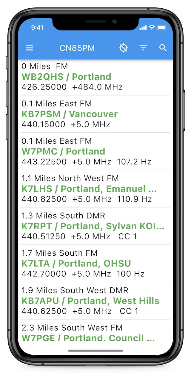
- RepeaterBook (iOS, Android, free) is the go-to app for finding local ham radio repeater listings and their contact details. It lists every nearby ham radio repeater and lets you filter repeaters by distance, band, service, and whether they’re affiliated with emergency networks like ARES.
RepeaterBook lists nearby ham radio repeaters. - EchoLink (iOS, Android, free) lets you chat (if ham licensed) with EchoLink compatible ham radio repeaters around the world. It’s a good way to practice your ham communications if you don’t have a physical radio or local repeaters.
- APRS.fi (iOS, $7) and APRSdroid (Android, $5) let you pair your physical radio (connected via a special cable) with your phone for things like text messaging and location tracking. More about APRS.
Map / navigation apps
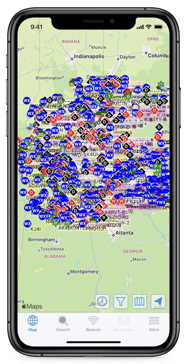
- Google Maps (iOS, Android, free) is the gold standard in free mapping. Downloadable maps for offline use, and the GPS works without a phone signal. It can show terrain, traffic, and even COVID-19 infection rates.
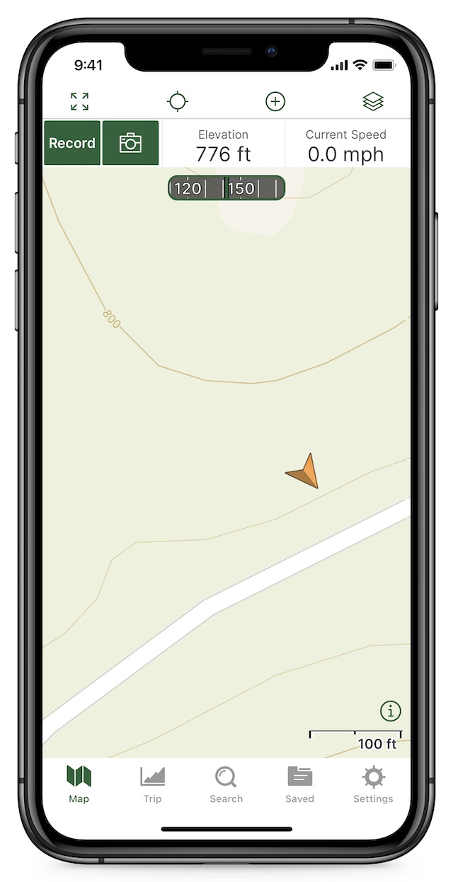
- Gaia GPS (iOS, Android, free with paid versions) contains a rich catalog of topographical, satellite, road, and NatGeo illustrated maps. Lots of no-connection features for the backcountry (or grid down). You can track your path, import local hunting maps, etc.
Gaia is an interactive topographic map that shows your elevation and direction. - Avenza Maps (multiple price options) is popular with the professional crowd, such as people who work out in rural areas. Many global maps available for purchase and offline download.
- onX (multiple versions and prices) is another popular mapping app, particularly among hunters who want to be careful about private property lines.
- Cairn: Hiking & Outdoor Trail Safety (iOS, Android, free with paid versions) automatically shares your location on your hiking trail with designated contacts so they know where to find you if needed. It even has a crowdsourced database of cell coverage locations so you know where you can contact friends or emergency responders.
- GasBuddy (iOS, Android, free) shows nearby gas stations and possible supply shortages. GasBuddy is the most popular gas price app, with more than ten times as many downloads as competitors, and since the information is crowd-sourced, having as many people updating prices is important.
- Familo (iOS, Android, free with paid version) is similar to Apple’s built-in “Find My” app for shared location tracking in Google Maps. What sets this app apart is that you can set up alerts to know when family members arrive to certain places, such as kids arriving home from school. One person buying a paid subscription includes unlimited tracking and sharing of location for all your friends and family.
Reference apps
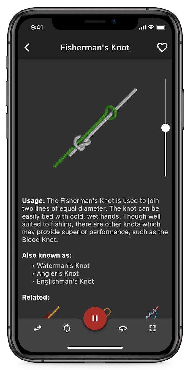
- Knots 3D (iOS, Android, $6) shows you how to tie over 150 knots, including uses and history. Organized by type, like camping, fishing, and pioneering, with 3D animations of each knot so it’s easy to learn and visualize how each is tied.
Knots 3D teaches you how to tie knots with 3D animations. - First Aid: American Red Cross (iOS, Android, free) gives short step-by-step advice for common medical emergencies. You can call 911 or locate your nearest hospital directly from the app.
- First Aid for Pets: American Red Cross (iOS, Android, free) just like the previous Red Cross First Aid app, but covers medical emergencies for cats and dogs. Plug in your vet’s information, find pet-friendly hotels, and take quizzes on animal first aid.
- Army Survival Skills (iOS, $2) and Army Survival Handbook (Android, free) digitize parts of the US Army survival manuals, with over 300 pages of information on survival medicine, emergency shelters, gathering food and water in the wild, building fires, poisonous flora and fauna, land navigation, knots, and common VHF frequencies.
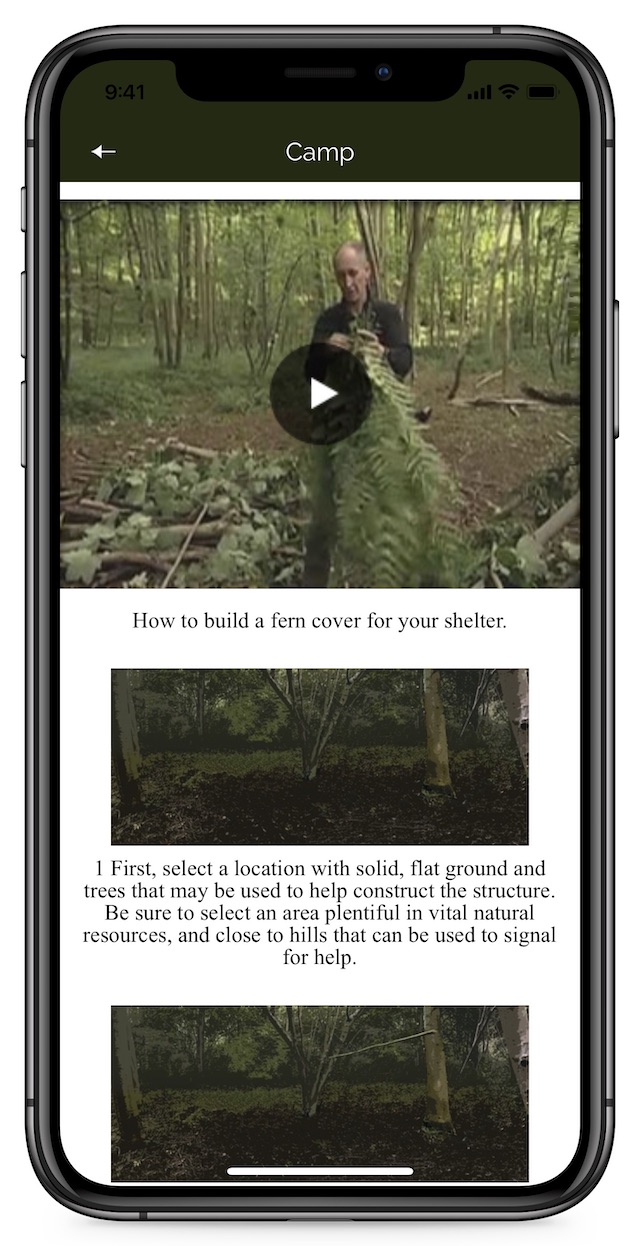
- SAS Survival Guide (iOS, Android, $6) includes the full text of the popular book, plus media and tools that use your phone’s sensors, eg. a morse code signaller and a sun compass.
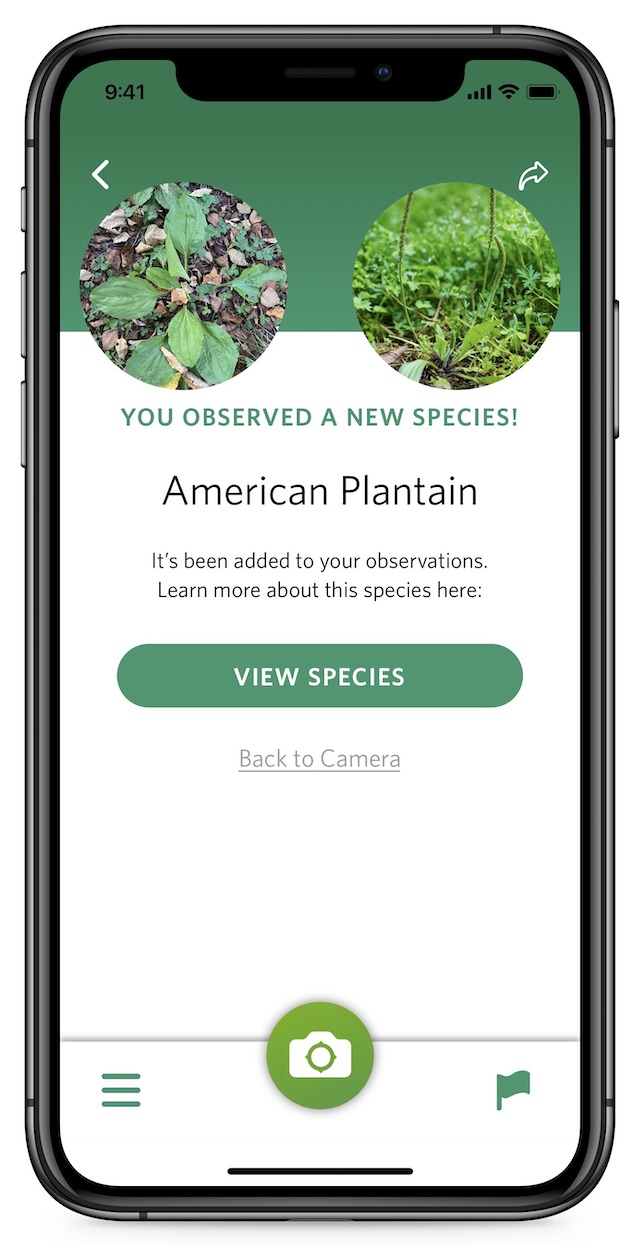
The SAS Handbook app is full of helpful photos and videos to teach you how to survive. - Seek by iNaturalist (iOS, Android, free) uses your camera to identify plants, fungi, and animals (or their tracks) based on a single picture. Requires connection to identify, but can store pics offline until you reconnect.
- PlantNet (iOS, Android, free) is similar to Seek, but lets you combine photos of pieces like bark, flowers, and leaves to get a more accurate identification. Seek is quicker, but PlanetNet can identify plants trickier to identify.
PlanetNet can identify wild plants based on multiple photos. - Wild Edibles Forage (iOS, $6) is an offline reference of over 250 plants, with photos, descriptions of how to find them, and recipes, compiled by some of the top experts in foraging.
Misc tools
- Compass Steel 3D (Android, free) is a compass that contains no ads or trackers whatsoever, which is actually rare for a compass app. iOS comes with a compass app, but Android does not. Can set true vs. magnetic north. Includes sunrise/set tracking info.
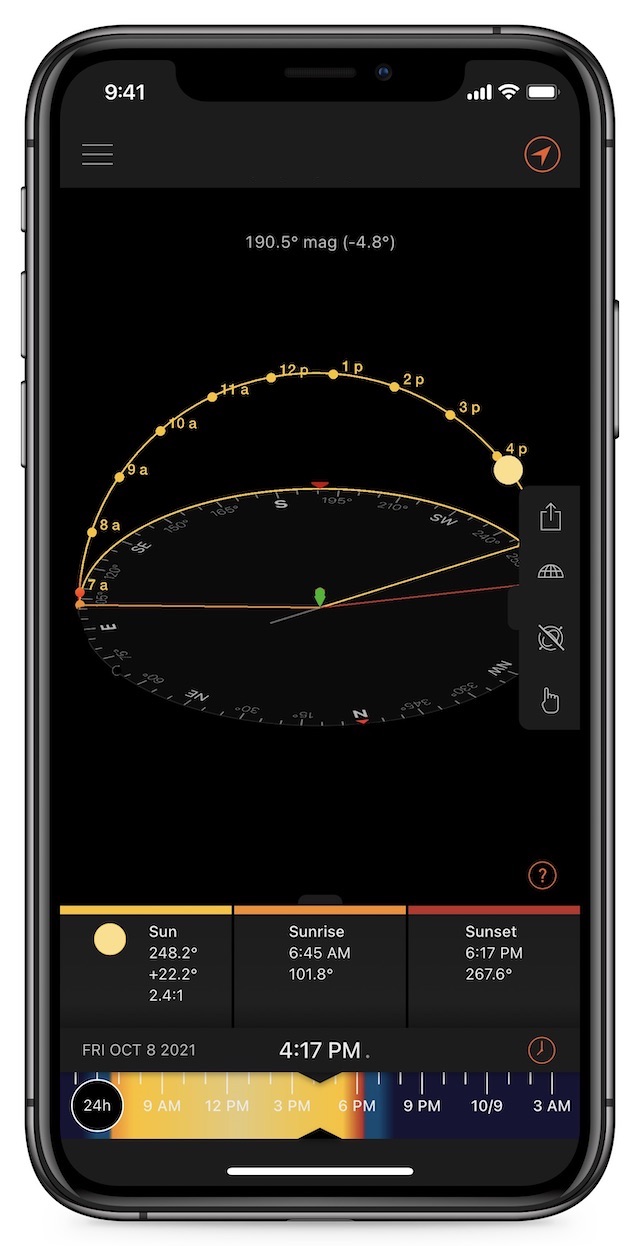
- Sun Surveyor (iOS $10, Android $8; free lite versions for iOS and Android) tracks the precise movement of the sun and moon over your location throughout the day with a 3D compass and ephemeris. It shows you how much daylight you have left and helps you plan sun-dependent projects like gardens and solar panels.
Sun Surveyor shows the sun’s position and path at your location. - iHunt 600 (Android, free) or iHunt 750 (iOS, free with paid features) plays over 600 different animal calls from over 55 species, ideally when paired with a Bluetooth speaker you can set further away. The 600 version is not available on the Apple App Store. The 750 version locks many features behind a paid plan. iHunt has a larger number and greater diversity of animal calls than any other app we’ve tried.
- Pantry Check (iOS, free) helps keep your pantry organized. If you go all-in on the FIFO storage method, this helps you stay organized with barcode scanning for quick entry, tracking percentages of items used, and it can sync shopping lists between family members.
Make it easy for first responders to help you by storing the right info
What if you’re in an accident and someone else finds your phone? Before phone passwords made it hard to open someone else’s device, first responders recommended prepending ICE (for “In Case of Emergency”) to important contacts in your address book — eg. instead of “Mom” as a label, you’d have “ICE Mom.” But that alone isn’t very useful these days since most people lock their devices.
Both major phone platforms have built-in features for storing ICE info that can be seen without unlocking the device.
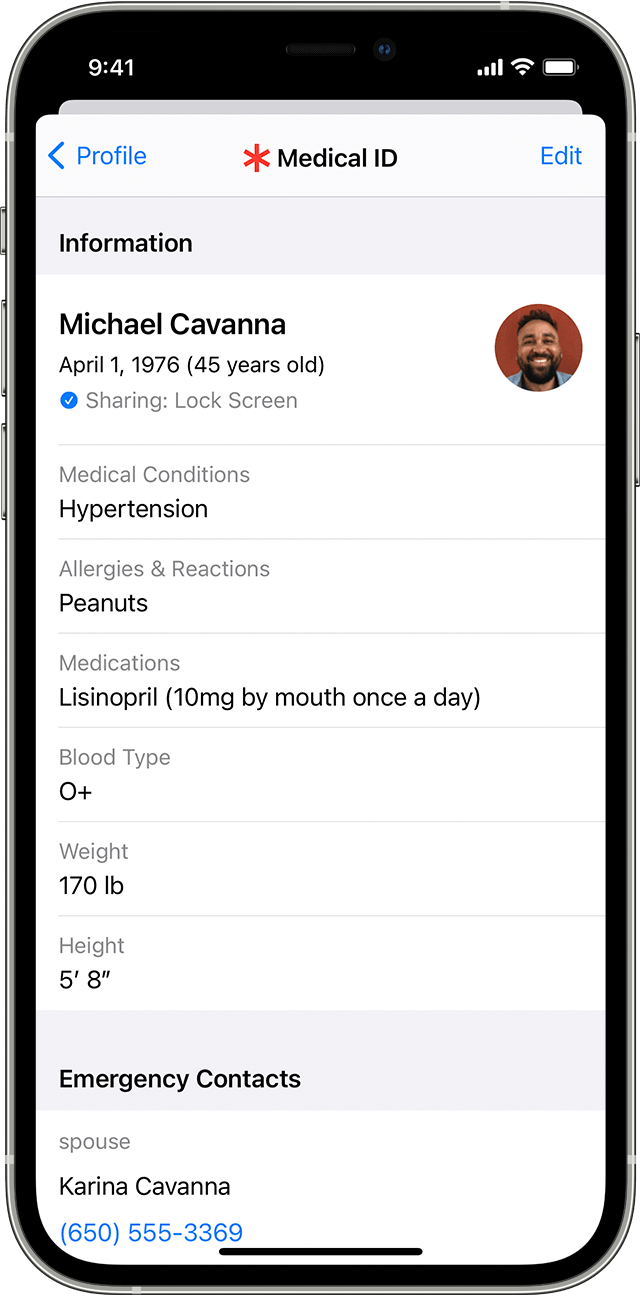
Set up Medical ID in iOS:
- Open the Health app
- Tap your profile picture in the upper-right corner
- Tap Medical ID
- Tap Edit in the upper-right corner and add your info
- Turn on Show When Locked and Share During Emergency Call
To reveal the Medical ID on most iPhones, press and hold the Sleep/Wake button on the left side and the Volume Up button on the left side simultaneously for a few seconds and then slide the Medical ID slider from left to right.
Note: Steps for Android may be different on your device depending on Android version and manufacturer.
Set up Emergency Information in Android:
Note: Android instructions can vary depending on device/version.
- Go to Settings > About Phone > Emergency Information
- Enter the information you want to share
- To automatically send your location when you make an emergency call, go to Settings > Location (or Security & Location > Location) > Advanced > Emergency Location Service (or Google Emergency Location Service) and turn on Emergency Location Service
To reveal Emergency Information, swipe up on a locked Android phone, tap Emergency > Emergency Information and tap Emergency Information after it flashes.
Tip: You can also add any information you like to your lock screen:
- Depending on your phone, either go to Settings > Display > Advanced > Lock screen Display > Lock screen message or Settings > Security
- Tap the Settings gear and then Lock Screen Message
- The intended use is to add contact information in case you lose your phone and a good samaritan finds it, but you can add whatever you like here
Know how to quickly call for help on iOS or Android
This is the same as manually calling 911 or another emergency number, so don’t trigger these features willy nilly.
Emergency SOS on iOS:
- Press and hold the Sleep/Wake (right side) and Volume Up (left side) buttons
- Slide the slider from left to right
- This makes two phone calls: the first to your local emergency service number (911 in the US) and then, after a countdown, it calls any emergency contacts you specified when you set up your Medical ID
Emergency calls on Android:
- Tap Emergency Call on the lock screen
Tip: If you use a Google Pixel phone, Google offers a free Personal Safety app that helps you contact first responders and share information with them.
Built-in emergency alerts on iOS or Android
These free tools are already built into your device’s operating system. But you shouldn’t depend entirely on them, because alerts aren’t sent for every event you should know about.
iOS emergency alerts:
- Go to Settings > Notifications
- Scroll all the way to the bottom and turn on Public Safety Alerts
- Tap Emergency Alerts and turn on Emergency Alerts and Always Deliver
There is also an option for AMBER Alerts in Settings > Notifications. The AMBER Alert warns you of child abductions in your area. It’s your choice to turn this on or not, but if you do, know they’re extremely loud.
Android emergency alerts:
- Go to Settings > Apps & Notifications > Advanced > Wireless Emergency Alerts
- Turn on the desired settings
- Since there is so much fragmentation between Android versions, the options may differ for each phone.
You can also enable earthquake alerts in Android:
- Only available in California, Oregon, Washington, Greece, and New Zealand
- Go to Settings > Location > Advanced > Earthquake Alerts
- Turn on Earthquake Alerts
Tip: If your phone can’t do the above steps, you can sign up for a third-party service that contacts you in the event of an emergency, without the need to download an app or have specific phone settings. For example, many cities have partnered up with CodeRED to push emergency phone calls, texts, and emails if there is a disaster in your neighborhood.