
A few readers asked us to share the list of resources our staff has been using to keep abreast of the on-going 2018 California wildfires and smoke — namely the Camp fire, now the worst in California’s history, and the Woolsey fire. This list isn’t intended to be exhaustive, and we welcome suggestions in the comments.
Tip: Millions of unprepared people are choking on the smoke. It’s important to protect your lungs (especially among the sick, elderly, and children). Stay inside when you can.
No matter how many people you may see wearing them, bandanas and the common surgical masks found in drug stores are not effective. Learn more about wildfire respirators, gas masks, and our recommended models.
News outlets
The best places for those of us not directly in the path of the fires to follow developments are the major news outlets with dedicated teams for tracking these events.
As with most things, the best news is local news, so we recommend the LA Times’ tracker page for the latest updates. The LA Times’ fire news feed is also worth following, as it has up-to-the-minute details and breaking news.
SFGate has a very good page dedicated to the fires. We would not have known, for instance, that the recently refinished Oroville Dam is under threat from the fire if it weren’t for that page. This is something to keep an eye on, because there are some 200,000 residents downstream from that dam who will have to move if starts to fail.
On a national level, the New York Times has a real-time feed of news on the fires, and a separate page with maps that show the progress of the different blazes as the days progress.
Maps and government resources
Mapping and analytics provider ESRI hosts two of the best real-time maps for the fires. One of the maps lets you track the fires themselves, and includes a traffic overlay that can be useful if you’re keeping an eye on your evacuation options:
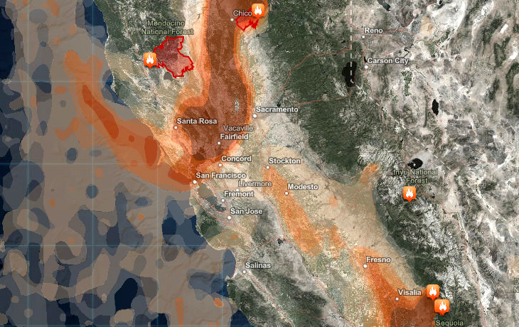
The other map gives you a real-time look at the spread of smoke over the region, with settings for changing the forecast time increments.

NASA also hosts a dedicated fire map with more features (and complexity) than the ESRI maps:
CalFire.gov maintains a Google Maps-based list of incidents that it’s working on. If you’re more comfortable with the Google Maps interface then you may like this map better than the more complex ones above. You can also click on the fires or on the list of incidents in the sidebar and get the latest news on them (i.e. link to incident reports and percent containment).
The Cal Fire agency also has an interactive evacuation map, but they warn you to take care in using it and to contact local police before making any moves.
One of the best maps for getting updated estimates on the size, location, and growth potential of fires is the Fire, Weather & Avalanche Center’s fire map. There are a lot of layers to play with, and plenty of detail. You can also create an account and save maps to it.
Other resources
The aforementioned CalFire website has a Current Incidents page that is a must-follow if you’re actually in danger from the fires. On this page you’ll get incident reports, evacuation information, and links to region-specific evacuation route maps. You can sort the page by fire name or county.
Another great resource is the Cal Fire mobile app, which gives you relevant push notifications and texts, and aggregates many of the resources on the Cal Fire site into a portable format that you may need if evacuating.
Finally, Twitter really is a great tool for updates in moments like this. Many of the fires have their own hashtags, like #PeakFire and #CampFire, where you can find near real-time news on road closures and other local events, interspersed with user-uploaded videos, news stories, human interest stories, and random celebrities who feel the need to spam up these hashtags with their profile pictures.
You should also be following the main Cal Fire account, along with the relevant Cal Fire account for your county (if you’re in the danger zone).